The terrain module is used to reconstruct a "terrain" map from discrete samples of its analytical description:
| z(r) = r2/8+cos(π r)/2 |
A central area is sampled at high resolution and the surrounding area at lower resolution to test the accuracy of the reconstruction scheme when mixing terrain datasets at high- and low-resolutions.
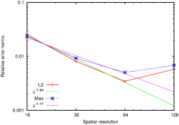
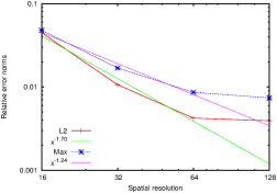
The reconstruction scheme converges initially but diverges when the maximum spatial resolution becomes finer than the sampling resolution of the (coarsest) terrain database. This divergence is due to smoothing errors when interpolating the terrain data from the coarse (database-resolved) grid to the fine grid. The errors remain low however.
Figures 155.(a) and 155.(b) illustrate the convergence toward the analytical solution of the terrain reconstructed using GfsVariableTerrain and GfsRefineTerrain respectively.
Figure 155: Convergence of relative error norms toward the analytical solution for terrains reconstructed using: a) GfsVariableTerrain, b) GfsRefineTerrain.
(a) (b)